|
Molokini is a crescent shaped islet located in the
'Alalakeiki
Channel about 3 miles off Maui's southwestern coast. Access is by boat only, and
charter boats operate out of Lahaina, Ma'alaea Harbor and Kihei. Molokini is the southern rim of an extinct volcanic crater. The shallow inner
cove is the crater's submerged floor. Black coral was once found in abundance in
the deeper waters around Molokini, but was harvested extensively. Harvesting is
now restricted, and small colonies can be found on the islet's back wall.
There is no sand beach on Molokini. The cove area slopes off from the
shoreline to a depth of about 100 feet before dropping off. The bottom consists
of sand patches, coral and basaltic boulders. A shallow reef in less than thirty
feet of water extends from the shoreline northward at the islet's northwestern
point. The diversity of fishes and other marine life within the MLCD is among
the most impressive in the state. Even humpback whales have been known to enter
the cove.
The back (southern) side of the islet has a steep face that drops off to
depths of over 200 feet. Small patches of coral are scattered across the wall.
Crevices and outcroppings harbor large populations of fishes.
 The
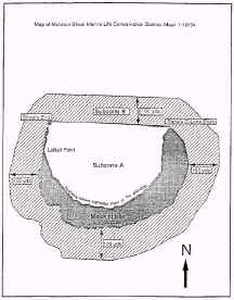
Molokini shoal marine life conservation district shall include subzones A and B
of that portion of the submerged lands and overlying waters surrounding Molokini
islet, county of Maui, as follows: The
Molokini shoal marine life conservation district shall include subzones A and B
of that portion of the submerged lands and overlying waters surrounding Molokini
islet, county of Maui, as follows:
(1) Subzone A is defined as that portion of
submerged lands and overlying waters within the crater, beginning at a point at
the highwater mark of Lalilali Point, then along the highwater mark of the northern
shoreline eastward until Pahee O Lono Point, then west along a straight line to
the end of the submerged ridge (shoal) extending from Lalilali Point, then along
the top of the shoal back to the point of beginning; and (2) Subzone 3 is
defined as that portion of submerged lands and overlying waters outside the
crater, encircling the islet out to 100 yards, seaward of the point of beginning
at the highwater mark of Lalilali Point then eastward along the highwater mark
of the southern shoreline of the islet to Pahee O Lono Point, then west along a
straight line from Pahee O Lono Point to the end of the shoal extending from
Lalilali Point, then along the top of the shoal back to the point of
beginning.
Safety considerations
Currents can always be a problem outside of the cove, and may get stronger
inside during the afternoon when winds pick up. When diving the back wall be sure to keep an eye on your depth gauge.
Facilities
None.
Molokini islet is a state seabird sanctuary, and entry onto the island is
prohibited.
Allowed activities
A person may (l) Fish for, catch, take, possess, or
remove any finfish by trolling in subzone B only; (2) Possess in the water, any
knife and any shark billy, bang stick, powerhead, or carbon dioxide (C02)
injector for the sole purpose of personal safety.
Prohibited activities
No person shall engage in the following activities
in the Molokini shoal marine life conservation district: (1) Fish for, catch,
take, injure, kill, possess, or remove any finfish, crustacean, mollusk
including sea shell and opihi, live coral, algae or limu, or other marine life,
or eggs thereof; (2) Have or possess in the water, any spear, trap net, crowbar,
or any other device that may be used for the taking or altering of marine life,
geological feature, or specimen; (3) Take, alter, deface, destroy, possess, or
remove any sand coral, rock, or other geological feature, or specimen; (4) Feed
or deliberately introduce any food material, substance, or attractant, directly
to or in the vicinity of any aquatic organism, by any means for any purpose; (5)
Moor boats for commercial activities; or (6) Anchor a boat when a day use
mooring system and management plan is established by the Division
of Aquatic Resources.
See the Administrative Rules for exceptions
and required permits for prohibited activities.
|
